Aerial Imagery and Historical Records
Last edited on 5 November 2024

Introduction
In this article, we talk about one of InQI's most exciting features: Historical Aerial Imagery. This feature enables you to see a history of your target property in pictures. You can see how things have changed over time. Furthermore, it allows you to discover aspects of the property that are only visible at certain times of the year.
Use Cases
Certain objects such as hardscapes are best visible during certain months of the year (depending on the region). A user who wishes to have maximum visibility over hardscapes will probably benefit from photos taken during the autumn months, again, depending on the region.
On the other hand, some other use cases may demand identification of canopies and drip-lines. Perhaps images taken during summer months would best match such use cases.
One can browse InQI's historical aerial images to find the image that best suits their visibility requirements.
How to Use This Feature
Open the
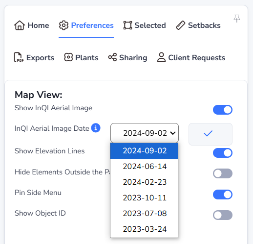
InQI provides you with at least one year worth of aerial imagery of the parcel and its neighborhood. Our records may cover a time span of up to two years. This could vary by region.
Note
After you request a older image, the older image
becomes your project default.
It will show up again when you reload the pages later on.
You can always switch back to the most recent image by choosing the top item in the list.
Things to Be Aware of
-
While InQI offers up to two years' worth of historical imagery data, our AI-based object recognition results are only valid for the most recent image of the property. This means that when you switch to an older aerial image, the AI-recognized elements will not update accordingly but rather stay unchanged.
As a result of this, if you wish to work based on a historical aerial image (not the most recent one), then please consider that the AI-generated element on the map might need extensive modification.
 It looks like you have discovered a premium feature!
Upgrade your subscription to immediately gain access to this feature.
It looks like you have discovered a premium feature!
Upgrade your subscription to immediately gain access to this feature.